
Free Sources of SAR Data
Free Synthetic Aperture Radar data can be some of the hardest to find, but it is out there if you look hard enough. These products are often provided in CEOS or other formats and there are a variety of tools available for working with the data.
SAR satellites and orbital paths
The most common way to receive SAR data, is a sensor on a satellite. The family of satellites that have carried, are carrying, or will be carrying SAR sensors for commercial applications are presented below.
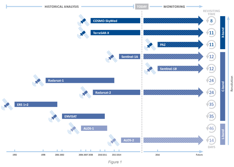
All satellites equipped with SAR sensors orbit the Earth on a near-polar orbit at an altitude ranging from 500 to 800km above the Earth’s surface, depending on the satellite platform hosting the SAR sensor. The time taken for a satellite to re-pass over the same area is called the ‘revisiting time’.
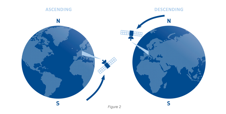
The angle between true north-south and the satellite orbit varies slightly, depending on the satellite, but in general lies in the range of 10 degrees. The circumpolar orbits of all SAR satellites mean that for half of their trajectory they are traveling from the north pole towards the south pole. This direction is referred to as a descending orbit. Conversely, when the satellite is traveling from the south pole towards the north pole, it is said to be in an ascending orbit.
Alaska Satellite Facility
This university provides a wide amount of tools to work with SAR data. The most reasonable is an API which provides a possibility to query data from different sources. The API includes search by products data from these storages:
- A3
- AI
- AS
- E1
- E2
- J1
- R1
- UA
- AIRMOSS – North American SAR coverage (via plane). There are 2-3 campaigns per year (depending on the length of the site’s growing season). During each site campaign, AirMOSS will collect data at least three times over a 10-15 day period to quantify evaporative and transpiration processes occurring at finer time scales over the study areas.
- AIRSAR – contains a wide range of data, covering different parts of the Earth (via plane). The first mission started at 1990 year, and finished in 2003. So, the ASF API provides access to this historical data, which not updating.
- ALOS – Japan satellite ALOS was launched in 2006. The satellite contained three sensors that were used for cartography and disaster monitoring of Asia and the Pacific (PRISM, AVNIR-2, PALSAR). In April 2011, the satellite was found to have switched itself into power-saving mode due to deterioration of its solar arrays. Its successor (ALOS-2) – was successfully launched in 2014, ALOS-2/CIRC data available here, all rasters have resolution 2m - 10m.
- ERS (ERS-1, ERS-2) – ERS-1 and ERS–2, were launched into the same orbit in 1991 and 1995 respectively with spatial resolution 30m. Both satellite deorbited. The similar to these satellites, ENVISAT, finished mission in 2012, due to losing connection.
- JERS-1 – was launched in 1992 from Tanegashima Space Center, and deorbited in 1998 due to techincal problems, had 30m resolution.
- RADARSAT-1 – a Canadian satellite, now it is inactive.
- SEASAT – Seasat was the first satellite designed for remote sensing of the Earth’s oceans with synthetic aperture radar. Its mission started and finished in 1978.
- UAVSAR – Similar plain mission to AIRMOSS and AIRSAR.
- SMAP (not found in the official documentation) – is a new satellite with a low resolution (1km - 36km)
- Also possible other SAR platforms, which listed neither here nor in the official documentation
This briefly analysis shows that ASF API provides really old or hardly refreshable data. The description of some products was not found, but it was found that this sources are old and can be used for historical research only.
Other satellites (with data not in a public access)
- PAZ/TerraSAR-X – The German TerraSAR-X satellite was launched in 2007 and reliably delivers high-resolution radar data for versatile applications to customers around the world. PAZ is the first Spanish radar satellite designed as a dual-use mission to meet operational requirements, mainly of a defence and security nature, but also high-resolution civil applications. The data is not available for free, though it it possible to observe, order or to request necessary data, also it is possible to become a commercial partner.
- COSMO-SkyMed – data is not available for public access, but it is possible to order products.
- SENTINEL-1/SENTINEL-2 – all products are availble in the Sentinel Scientific Data Hub.
- RADARSAT-2 – it is possible to order data.
- ALOS-2 – was successfully launched in 2014, ALOS-2/CIRC data available here
These satellites have the spatial resolution up to 1m.
Epilogue
What is in the end? ASF API is a sort of SAR data sources aggregation. The only public actual data (free and in public sources, found during this small research) is provided by ALOS-2 satellite, but, there are no sources (or were not found) providing the daily whole earth coverage.
NOTE: it is possible that not all available sources are mentioned here, comments below the post are highly appreciated.
List of all launched satellites: https://www.wmo-sat.info/oscar/satellites